The Real Vinland.
The world believes that Newfoundland was the place where the Vikings first landed in the New World.
No it wasn't: I track down the real location -- which to this day is still unexplored.
When Christopher Columbus landed in the Americas in the year
1492, his historic arrival, experts maintain, signalled one of the greatest
feats of human endeavour and discovery ever performed, the one defining moment
in world history when, for the first time ever, the red men of the New World gazed
upon the white men of the Old. And in the centuries which followed, Columbus
took the entire credit for the 'discovery' of the New World and became, in the
eyes of many Europeans, the first to step onto her shores.
But Columbus himself had known that in the dim and distant past, even from his
own standpoint in time, there had been legends and stories about a great land
across the western sea, and he had known that the Viking sagas, with which he
was very familiar, spoke not only of such a land but also, in detail, of how to
get there.
And then of course there was that mysterious painting, dated circa 1260 AD, on a wall in the ancient cathedral of St. Peter in Schleswig, Germany, close to the border with Viking Denmark. It depicts eight turkeys. But turkeys don't come from Europe, they come from America. And this picture predates Columbus by almost a quarter of a millennium.
Now Columbus had certainly heard, and perhaps even seen for himself on old maps now lost, that the coastline of this new land ran roughly from NNE to SSW -- just as did the coastline from Eastern Russia down towards China. Suppose, he mused, that these two coastlines were one and the same, and that Eratosthenes had been wrong when in ancient times he had measured the circumference of the earth, and the world was actually smaller than he thought? Why, if this were true, then the journey time to India would be far less if we travelled west from Europe, rather than east.
And so, his own country of Italy being divided in those days into many small states, none of which were particularly flush, he went to Spain, Ferdinand and Isabella'd himself some money, and set off to cross the Atlantic, bound for India. His navigator had projected the mystery NNE-SSW coastline further south, down into the more southerly latitude that they were travelling on, and 2 days before they sighted land he had told Columbus that it would be "land-ho" in 2 days time. Not bad. They must have realized that they had indeed found a quick way to India and the Indies, and they soon began calling the American natives Indians, a name which had already stuck by the time they discovered their mistake.
But what of those ancient Viking (Norse) tales? Where exactly
did the Norse go?
Well they left behind many sagas, stories which were not originally written down
(the German word sagen, for example, means to speak), but to alter
them even slightly would have been sacrilegious. A few centuries later they were
put
into written form. And of these there were two, the Saga of Eirik
the Red, and the Greenlanders Saga, which speak in some detail of the
Norse voyages to
America.
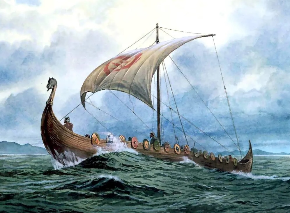
Eirik Thorvaldsson Rauda, later to become known as Eirik the Red, was a red haired, bad tempered, rough hewn man, and in about 960 CE he was thrown out of the Faeroe Islands where he had settled, and so, having already been chucked out of Norway he made his way west and settled in Iceland. Well it wasn't long before he was expelled from there too (he must have been a right case), and so, with nowhere left to go, he just blindly sailed west with his family and a few hopeful colonists -- and discovered Greenland. There they made their home, his family and his people establishing two villages, Godthaab and Brattalid, which were also called the Eastern and Western Settlements, and it was here that the Eiriksson children, sons Leif and Thorvald, and daughter Freydis, grew up.
Then, one day in about 999 CE, a ship load of exhausted colonists came limping into the Western Settlement where the Eirikson farmstead was located, and disembarking there the commander, one Bjarni Herjolfson, told Leif Eirikson about how he had set off from Iceland to settle in Greenland but had been blown off course in a storm which had driven their ship far to the southwest, and in an effort to regain his latitude he had passed by a vast and entirely new land, dominated by great snow-peaked mountains, long white beaches and towering forests. He had not set foot ashore, but we can well imagine the enthusiasm with which the two youths must have talked, as Bjarni described in detail the land he had stumbled upon and how it could be reached, by his reckoning, in less than a week's sailing to the southwest.
And so, in the following summer, 1000 CE, Leif prepared a ship and with about 50 volunteers he set off to find this mysterious land -- and here we get our first clues as to exactly where they went. The saga of Eirik the Red states:
They sailed away from the Western Settlement, and for Bjarnijar (located futher north along the west coast of Greenland), and then followed a north wind, and were at sea for 2 days, and then found land. They explored the country, finding great stone slabs, many twelve ells (18 feet) wide. There were also many white foxes there. They gave the land a name, calling it Helluland.
Today, experts all agree that they had landed on one of the eastward pointing promontories of Baffin Island, so they must have sailed north along the west coast of Greenland to begin with, in order to compensate for the southerly setting currents in those waters, before then turning south and going with the current and the north winds.
Now the saga continues:
(From Helluland) they put to sea with a north wind, and soon found a second
land. They sailed into the coast and cast anchor, lowered a boat and went
ashore. The country was flat and wooded, and wherever they went there were flat,
sandy beaches sloping gently down to the sea. Some of the trees were big enough
to be used in house building. Then Leif said, "We shall give this land a
name", and they called it Markland (Wooded-land). And again they returned to
their ship.
Now at this point it is easy to imagine that they had sighted the towering forests of Labrador, which is where almost all modern scholars believe they were. But were they? Read on....
Again the saga continues:
From there they set out to sea once again, before a nor'westerly wind, and
were at sea for two days before catching sight of land. They came upon an island
which lay to the north of the mainland, where they went ashore and looked around
in fine weather. After this, they sailed into a sound which lay between the
island and a cape which was to the southward and which projected north from the
mainland. They sailed through the sound and westward past the cape
(underlined italics mine -- read on). At low water there were great shallows
there. They went aground at one place, and thought it was a very long way to
look to get sight of the sea from the ship.
But they were so impatient to explore the land that they had no mind to wait until the water rose under them, and they ran ashore at a place where a river flowed from west to east out of a lake. Then when high water came they took their ship into the river and so into the lake, where they carried their belongings ashore and put up booths. Then they decided to winter there and built a large house.
Now this place, wherever it was, was later to become known as Vinland -- Viking America, and their new settlement they called Leifsbudir. But where exactly, on the modern map, was it?
Then in 1960, the Norwegian explorer Helge Ingstad and his wife, archaeologist Anne Stine, discovered the ruins of a large Norse settlement at L'Anse aux Meadows in Newfoundland, almost at the northern tip of the Northen Peninsula,a long north-protruding cape in the island's northwest. Dendrochronology tests gave a precise date of 1021 CE, just over 2 decades after Leif Eirikson -- and the world celebrated the rediscovery of the lost Vinland of the Norse sagas.
After all, didn't the sagas say that the Vikings came down from the north and fell upon a cape projecting north from the mainland? It all seemed to fall into place: the icy first land was Baffin Island, and the second must have been the towering forests of Labrador while the third, Vinland itself, must be on the northern end of the cape in Newfoundland, exactly where the Ingstads found the ruin!
However, in the excitement of this discovery -- and an extremely profound discovery it was-- many glaring departures from the original Viking sagas were overlooked, and remained ignored for 10 years until another man, this time a mathematics and physics qualified researcher named James Robert Enterline, came upon the scene and, with his sharp, rationalizing mind, he turned this newly established picture upside down.
Enterline began however by effectively pointing out that if we draw on a piece of tracing paper the course taken by Leif Eirikson as described in the sagas, with reference to the compass directions and the sailing times mentioned, and then superimpose this onto a modern map of the region, the final destination is nowhere near Newfoundland. Second, the original Vinland was reached by sailing into an east-flowing river and then into a lake, which L' Anse aux Meadows certainly is not, and third, as we will later see, the Vikings sailed away from their settlement at Vinland and went east and then north, to arrive at a cape, whereas if the same course is taken from L' Anse aux Meadows we end up in the middle of the Atlantic. L' Anse aux Meadows just didn't fit.
There are also many other geographical departures from the Newfoundland theory, so let's take a closer look at the sailing directions in the sagas, with reference to some modern maps of the general region:
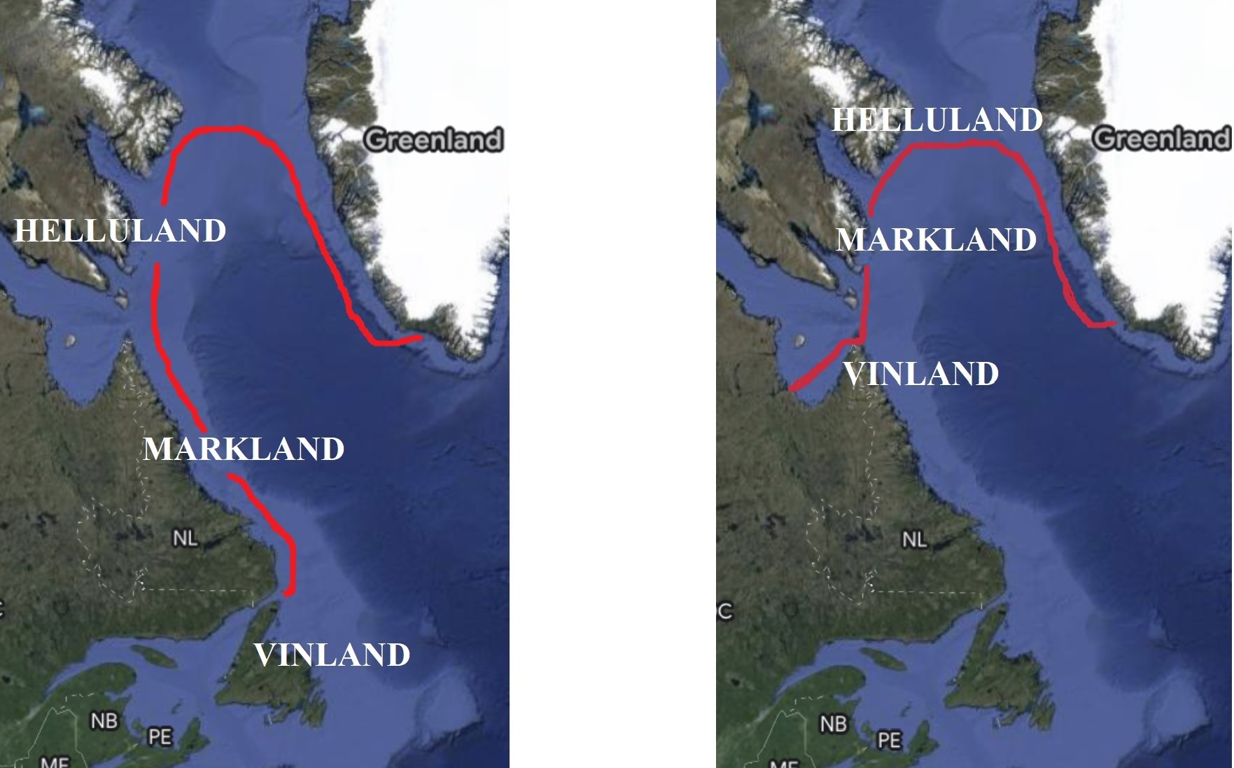
The course taken by the Vikings on their historic first
voyage to North America.
According to the Ingstads (left), and according to Enterline (right).
As to which is correct, the sagas clearly state that the Vikings came down from
the north, to the top of
a north-projecting cape, and then sailed west around it. The Ingstads
claim that the cape is Newfoundland's Northern Peninsula, where the settlement
of L' Anse aux Meadows is actually situated. Enterline claims that the cape is
Cape Chidley, far to the north of Newfoundland. The sagas imply that Vinland was
not located on a cape and state that it was in a lake in a west-to-east flowing river.
The case for Ingstad's Vinland in Newfoundland.
The Ingstad man and wife team discovered the Norse settlement of L' Anse aux Meadows in 1960. It is located at the extreme northern end of Newfoundland's Northern Peninsula. Now the sagas did say that Leif Eirikson descended from the north and fell upon a cape, which projected north from the mainland, and material from the oldest part of this settlement was dendrochronologically dated to 1021 CE, that is, about 20 years after Leif's original voyage. Ingstad also identifies the 2 lands that Leif encountered en route, as Baffin Island (Helluland), and the towering forests of Labrador (Markland), which the Norse did say was populated with trees big enough to be used in house building.
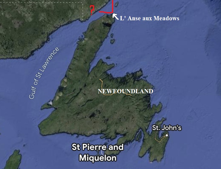
The Viking settlement of L'Anse aux Meadows at the northern
tip of Newfoundland. The sagas did say that Leif came down from the north, and
fell upon a cape which projected northwards from "the mainland".
However Newfoundland is an island not mainland and in any case the sagas
continue that Leif sailed away westwards from the cape, where he encountered
very extensive shallows, (and established Vinland in a lake where a river flowed
from west to east). There are no such shallows west of this cape and no such
river or lake.
It has been countered that the sagas may not be entirely accurate. But it would
have been sacrilege to alter them, and
Enterline's location, further north, fits to a tee.
The case against.
However, the sagas clearly stated that Leif, having come down to the north-projecting cape, then steered around the cape and to the westward, eventually arriving at a place where there were great shallows and where a river fell down from the land from west to east, and contained a lake into which they sailed and built their settlement.
L' Anse aux Meadows does not lie in a river or a lake, and is actually located on the northern extremity of a cape, whereas Leif said he steered westward away from the cape and sailed on, before establishing Vinland. Also there are are no great shallows in any place west of Newfoundland's Northern Peninsula.
Further, the sagas go on to say that the following summer when Leif's brother Torvald's party went exploring, they sailed away from Leifsbudir, headed east and then north, and came to the end of a cape. However if we do this starting from L' Anse aux Meadows, we end up in the middle of the Atlantic Ocean, far from any land.
The sagas also said that there was a very lofty mountain range, with snow-capped peaks, along the length of the cape/promontory.
This does not fit Newfoundland at all.
The case for Enterline's Vinland in Ungava Bay.
After a careful and very methodical analysis, Enterline concluded that the northward projecting cape which Leif encountered was in fact Cape Chidley, which has almost all along its length a lofty mountain range, today called the Torngats, which also has many snow capped peaks. Acknowledging that Leif then sailed west from their cape, Enterline draws our attention to the very extensive shallows over on the western shore of Ungava Bay, the body of water which Leif would have entered immediately after leaving Cape Chidley.
At this place is a river, the Leaf River, which flows from west to east out of a lake -- exactly as the sagas said. Further, if we then follow Leif's brother Torvald in his subsequent summer exploration, and sail east from Leifsbudir and then north, again as the saga says, then we indeed come to a cape - the very same Cape Chidley.
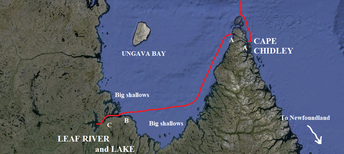
Enterline's scenario: The sagas state that Leif came down from the north, to fall upon a cape which "projected northwards from the mainland". They then state that he sailed through a sound (A-A) between the cape and the island immediately north of it, and then west to a place where there were great shallows (B, extensively reported upon in he Arctic Pilot) and where a river flowed from west to east out of a lake (C), and that Vinland was in the lake.
Torvald then said that, after repairing the keel of their ship on the cape, they steered east along a passage which lay between the end of the cape and an island to the north of it, and then into the mouth of the next fjord they came to. One saga adds that this was actually the joint mouth of two fjords. Incredibly, if we retrace this on a modern map, we first travel east from Leaf River and along the south shore of Ungava Bay, before turning north to the end of Cape Chidley. Then we steer east, along the passage between Cape Chidley and the Killiniq Island, and then into the mouth of the very next fjord -- which is indeed the joint mouth of two fjords!
The sagas yet further stated that on the headland between these 2 fjords, Torvald was killed in a fracas with natives and was buried right there.
The case against Enterline's hypothesis.
To be honest there really isn't one. It had been pointed out that the trees (which the sagas say were large enough to be used in house building) are very small in the Leaf River area because it lies above the tree line, and that the towering forests of Labrador, on the way to Newfoundland, must therefore have been the Markland of the sagas, which effectively eliminates Enterline's Leaf River hypothesis. However, the building of a Viking house only necessitates 2 poles, each about 4 inches in diameter and 9 feet high, to hold up the ends of the roof while the rest is of wattle (small interwoven branches and twigs) or stone and turf. Trees of this size are abundant in the Leaf River area above the tree line, and the huge trees of the Labrador forests would have been entirely superfluous to the building of a Viking house.
And yet, the enthusiasm for the Newfoundland site remains so great, that no exploration of the Leaf River area has ever been carried out, and so the likely real location of Leif Eirikson's original Vinland and the ruins of Leifsbudir remain undiscovered to this day, as does the lost grave of his brother Torvald on Cape Chidley.
So where do I come into all this? Going beyond Enterline and the discoveries I made.
Now Enterline never definitively stated exactly where he thought Leif's settlement was, and upon researching this mystery I discovered that he had actually made a couple of mistakes, the solutions to which have given me in his stead the opportunity to pinpoint, on the map at least, the original Vinland and the settlement there, the first European one in the Americas (Leifsbudir), and also to precisely locate, again on the map, Torvald's lost grave.
The first of these 'mistakes' is actually more of an omission. Enterline traces Leif's voyage to the Leaf River, and mentions that Leif entered the river and then the lake -- but then he puts down his pen. Had he continued, he might have noticed what I subsequently noticed, that Leif's direction in going up the river and into the lake would have taken him, upon entering the lake, directly to the largest island in the lake, a place which today bears the rather unromantic name of Helicopter Island. Now we already as good as know that the original Vinland was an island, because the sagas yet further relate that one night, the Vikings were attacked by the local natives, whom they called the Skraellings, and after this attack, which failed, these natives 'ran back to their boats', which presumably would not have been necessary had it been a mainland-to-mainland attack. Settling on an island also makes perfect sense for just that reason -- the hostility of the natives. This is almost certainly the reason the Vikings did not stay permanently in North America; the natives were too numerous and the Vikings, coming only from the Greenland settlements, lacked the numbers to establish a proper beachhead, confining themselves instead to islands which afforded them the protection of the surrounding water. Notice that the Helicopter Island Leifsbudir candidate and L' Anse aux Meadows are both on islands.
The sagas also tell of a member of Leif's expedition called Tyrkyr, a German who had actually been employed by Leif as a scout. Now when the ship landed at Vinland, Tyrkyr ran ashore and went on ahead of the rest of the party, to be subsequently discovered by his compatriots on top of a large crag. After an exhaustive search I discovered that the only real crag in the entire region is located -- have a guess -- on Helicopter Island.
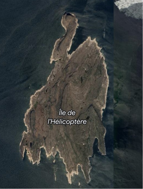
Helicopter Island in Leaf Lake, Ungava Bay. The largest
island in the lake and the only one big enough to accommodate a colony, it also
possesses the only significant crag in the entire region.
So this island has never been explored as a possible location for the original Vinland of Leif Eirikson, despite it's position at the very end of the sagas' sailing directions, despite its being an island as we know that Vinland was, and despite it being the owner of the only crag in the entire region.
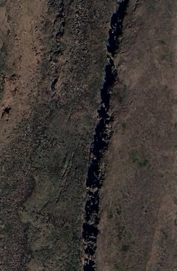
Part of the substantial crag on Helicopter Island. Tyrkyr, a member of Leif's expedition, went ahead of the exploratory party and was later found on a large crag. Interestingly, if we begin at the natural fjord-type anchorage at the northern end of the island, and walk south, we come to some mysterious ruins (not explored) which I discovered on a satellite map. If we then continue for a short distance in the same direction, we come to a large and prominent crag, which further investigation of the satellite imagery revealed to be the only sizeable crag in the entire region. "I didn't go much further than you," Tyrkyr told Leif Eirikson. Is it possible that Leif and the main party halted while Tyrkyr went on ahead, while they considered a promising place to build Leifsbudir?
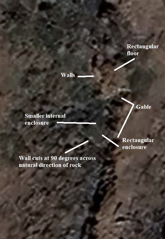
Are these European ruins? If so, what are they doing on an uninhabited island in the remote Arctic? These ruins, which I discovered using satellite imagery of Helicopter Island, are completely disconnected and cast adrift from any modern societal structure. They do, however, lie at the very end of the sagas' sailing directions to Vinland. Enterline believes that the Norse occupied Vinland for about a century, before yielding to the popular sentiment among them that the natives were too much of a handful. Coming only from their Greenland settlements they had never built up sufficient numbers to establish themselves in Vinland, and had had to confine their settlements to islands.
The second mistake of Enterline's was just that -- a genuine error. Had he not made it, the lost grave of Torvald Eirikson might have been discovered decades ago. But as it is, the grave remains lost to this day. Enterline's mistake is that in tracing the course of Torvald's summer exploration from Vinland, east along the south shore of Ungava Bay and then north to Cape Chidley, he has Torvald sailing east past Cape Chidley and around the large island (Killiniq Island), to its north, thinking that the whole thing was Cape Chidley and missing the small passage between the island and the cape (see pic below).
And so, instead of tracing Torvald around Cape Chidley proper, then east along the passage and into the mouth of the next fjord he came to, which as the Graenlendinga Saga points out was actually the joint mouth of 2 fjords, Enterline has him sailing around the top of Killiniq Island and into what is now the Terence O' Brien harbour on that island, which is definitely not the joint mouth of 2 fjords.
To be honest, as a fellow researcher who also has a scientific background, I was aghast when I discovered this error.
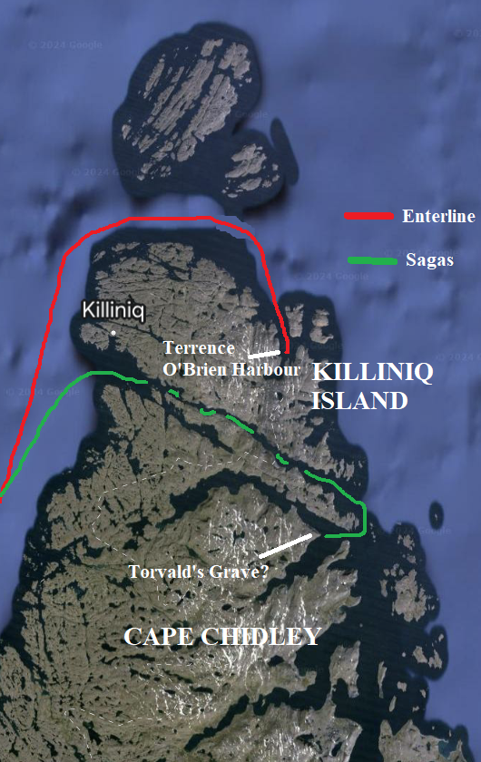
Enterline's major error: The sagas say that in
the summer following their establishment of Vinland (probably Leaf River and Lake), which is off to the bottom
left of this pic, Leif's brother Torvald sailed east from Vinland and then north until he came to
a cape (Cape Chidley). According to the sagas Torvald then followed the course outlined in green,
which took him through the narrow sound which separated the Killiniq Island from
the actual cape, and then into the mouth of the very next fjord he came to (end
of the green line), which the Graenlendinga Saga expressly states was also the joint mouth of 2 fjords. Upon the
headland between these 2 fjords, Torvald was killed by natives
and was buried. The Norse called the burial place Krossanes, which means the promontory
of the cross, Torvald's last dying wish having been to be buried with
crosses at his head and feet.
Enterline, however, completely misses the narrow sound between island and cape,
and has Torvald sailing the red course -- taking him around both island and cape
and into the Terrence O' Brien harbour which lies at the end of the red line.
Due to this error, Torvald's grave remains lost and the headland between the 2
fjords -- which it has been left to me to identify -- has never
been searched for it.
I would love nothing more than to visit this region and finish what I have started here, namely the continuation of Enterline's work to a fitting conclusion, and in so doing I would especially love to locate the lost grave of Torvald Eirikson, son of Eirik the Red, brother of Leif Eirikson, and return his remains to the (now discovered) Eirikson family graveyard in Greenland.
-- Michael Alan Marshall (Researcher)
For further reading. You will need to sign in to read these online; however physical copies are of course available.
"Westward to Vinland", by Helge Ingstad, (1969)
eBook here: Westward
to Vinland : the discovery of pre-Columbian Norse house-sites in North America :
Ingstad, Helge, 1899- : Free Download, Borrow, and Streaming : Internet Archive
"Viking America: The Norse Crossings and their
Legacy", by James Robert Enterline (1972)
eBook here: Viking
America ; the Norse crossings and their legacy : Enterline, James Robert : Free
Download, Borrow, and Streaming : Internet Archive
"The Vinland Sagas: The Norse Discovery of
America", by Magnus Magnusson and Herman Palsson, (1965).
On page 60
of this work is contained the astonishing revelation that the fjord that
Thorvald Eiriksson sailed into after repairing his keel, being the first fjord
one comes to after rounding the cape, was in fact the joint mouth of 2 fjords,
which combined with the fact that they were at the head of a cape, after sailing
east and then north from Vinland, verifies the location of Vinland as the south
west corner of Ungava Bay which, sure enough, has there a river which flows from
west to east out of a lake, over extensive shallows -- all exactly as the Saga
of Eirik the Red and the Graenlendinga Saga both relate.