The Mystery of King John's Lost Crown Jewels
On
October 12, 1216, one week before his death, King John was navigating
the treacherous windswept fens of Lincolnshire, when in a tragic encounter
with the tide while crossing the Wellstream estuary
he lost his entire regalia
and all his treasure, together with the money to pay his soldiers.
Despite
many search attempts, none of it has been seen since.
I
make a ‘pivotal’ discovery – the tide had been going the other way –
which has wrong-footed every search ever made.
And in 1980 I found the cause – a tidal surge which was lost to history when the estuary was reclaimed from the sea.
In
1216, the 17th year of his turbulent reign, John Plantagenet, King of England,
was embroiled in a civil war. His Barons mostly against him, and foreign
mercenaries marching all over his kingdom, he found himself surrounded by a mire
of intrigue and plotting in which from one day to the next he was no longer sure
of just who was with him and who was not.
And
so, he gathered vast his treasures from their various depositories all over the
realm, and carried it everywhere with him in his long, ox-drawn baggage train.
The inventory of his treasure still exists. It reads like something from the
Arabian Nights:
143
silver cups (1 jewelled with sapphires) and 14 goblets 14 dishes, 8 flagons, 5
pairs of basins, 40 belts fitted in silver and gold, 6 clasps jewelled with
garnets pearls and precious stones,16 staffs studded with rubies, sapphires,
diamonds, garnets, topazes and emeralds, 51 rings set with rubies and sapphires,
1 episcopal ring with a great sapphire and pearls and garnets, 2 pendants, one
with 9 sapphires and one with a bedewin stone,
a citrimum stone
and a pregnant stone, 4 shrines of the saints, being a silver shrine set
with onyx and other stones, a small ivory shrine, a red shrine with jewels and a
shrine of jewelled gold containing a gold cross with 3 sapphires formerly
belonging to the Lord of Chester, 2 gold crosses,3 gold combs, a gold vessel
ornamental with pearls (a present from the Pope), 2 candelabra, 2 thuribles, 3
golden phylacteries, silver vessels to the weight of 220 pounds, besants and
other gold weighing 5 pounds, 4 great mazers with gilded feet and bands,
the Great Crown of the Empress of Germany (John's grandmother), a belt of
embroidery with stones, a brooch of gold, a great sceptre of the same regalia, a
golden wand with a dove at the top, 2 swords, to wit the Sword of Tristram and
another sword of the same regalia, a golden spur of the same regalia, a cup of
gold 13 pounds weight, a cross of gold 6 pounds weight, 1 wand of gold
with a cross, a red belt with precious stones, 1 belt of black leather with
precious stones cut and set in a chase, 1 leather belt padded with red sendal
with great stones in a chase, 1 belt of red leather padded with white leather
with great stones set in a chase, 1 belt of black leather with roses and bars of
gold without stones, a necklace set with diamonds surrounded by rubies and
emeralds, 9 great necklaces with many precious stones, a crown with precious
stones with a cross of seven flowers, a royal tunic of red samite with precious
stones in orles, 1 pair of gloves with stones and another pair with flowers of
gold, 1 tunic of red samite with stones great, diverse and precious, 2 brooches,
11 pairs of basins weighing 104 pounds, the Great Crown of England,( gold,
adorned with precious stones), golden spurs, a wand of silver and gilt, the
Sceptre ,of gold, a tunic with dalmatic of red samite with a collar of stones in
gold work, a belt with gold fittings with stones, a pallium of red samite with
stones, a gold ring with rubies, 2 gold brooches one with a sapphire and one
with a pearl, 1 pair of sandals of red samite with gold work, 2 laces of gold
work for lacing the King's sandals, 1 pair of sandals with gold work, 5 swords,
(2 covered with gold work), .......and 2 pairs of gloves.
In
addition to all this there would also have been a great many sacks of coin,
enough for the payment of all his troops and retainers for months ahead, as he
no longer thought himself safe, and took great care to take with him all that he
could.
In
October his campaign took him into predominantly rebel country: the Fens of East
Anglia. On the 11th, he was at King's Lynn on a
march which would take him through some of the
swampiest, most treacherous country in England. Next day, the 12th, on the way
from there to Swineshead, disaster
struck.
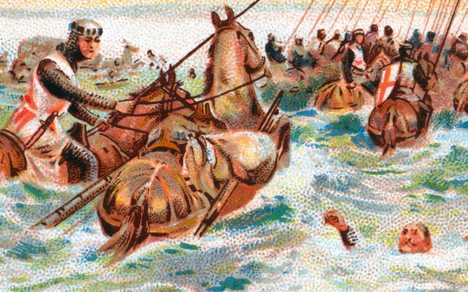
Arriving
in the early morning at the banks of the wild and unpredictable Wellstream river
estuary, only a short distance from where it flows into the sea, his treasure
train set out upon the treacherous quicksands over
which the river ran. Here Matthew Paris, writing in the Historia Anglorum,
(c. 1250), reports:
"King
John, heading for the north, attempted to cross, without a guide, the place
where sea and river water mingle, known as the Wellstream,
and narrowly escaping himself, he lost there irretrievably the carts and
packhorses bearing his treasure and loot, and all his treasures and household
effects. For the ground opened in the midst of the waves, and the sand which is
called quick sucked in everything -- horses and men, tents, victuals, and all
the things which the King valued too highly in this world, apart from his
life."
Roger
of Wendover, in the Flores Historiarum,
(1235), wrote,
"
Then, heading for the north, he lost, by an unexpected accident, all the wagons,
carts and packhorses, with the treasures, precious vessels and all the other
things which he cherished with special care; for the ground was opened in the
midst of the waves, and bottomless whirlpools engulfed everything, together with
men and horses, so that not a single foot-soldier got away to bear tidings of
the disaster to the King. The King, however, barely escaping with his life,
spent the following night at the abbey called Swineshead."
At Swineshead John
was suddenly taken ill. Dysentery was diagnosed, apparently from "supping
to greedily on peaches and new cider" at King's Lynn. Wracked in pain he
was carried on a litter to Newark, near Nottingham, where on the 19th, just a
week after his great loss, and as a great storm ripped around the rooftops of
the town, he died, leaving his war-torn kingdom in the hands of his little 9
year old son.
So
great had been the disaster that 9 days later at Gloucester, when little Henry
III stood upon the High Altar, holding his mother's hand, they placed a small,
hurriedly made circlet of gold upon his head, the Great Crown being lost. He
promised to be good, to uphold the Laws, and be every man's Sovereign Lord. Such
was the spectacle of this that the Barons finally reunited and many of them,
despite having become hardened by years of war, were moved to tears. He
went on to reign for 56 years; only the later reigns of George III, Victoria and
Elizabeth II were longer.
And
so, England continued, towards other -- and worse-- adventures, and the disaster
which had befallen John passed into history.
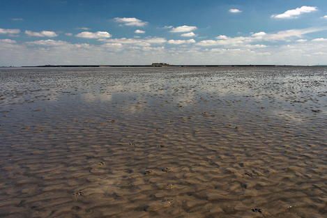
But
then, four hundred years later in the17th century, the people in those remote
parts began to slowly reclaim the flat, marshy land from the sea. A series of
sea banks was built and the wild Wellstream,
which when the tide was out would flow over sands so flat that it would change
course every time a wind got up, was embanked and the land either side of it
drained.
These
reclamation projects would, off and on, span another 200 years until the coast
finally took on its present outline the middle of the 19th century. Today
the sea lies far out from the coastline of John's days, and the fateful scene
of his disaster is now most certainly dry land.
We
can reconstruct the old coastline as it must have been then, by reference to
accurate Ordinance Survey maps of the area which still demark the ruins of the
old sea banks. There are many of these, left to rot and erode
away as later, newer banks were built nearer the sea.
Tracing these and joining them up on the map, I looked on, as a place
miles inland with the puzzling name of Walpole Island
again became just that, an island, and then to my amazement -- and to my
horror-- the ancient estuary itself again began to take form before my very
eyes.
It
was delta shaped, and ran north from Wisbech, fanning out as it went, the east
bank running past West Walton, Walpole St. Peter, Walpole St. Andrew and
Cross Keys, before turning east and joining the sea. The west bank ran to Tydd Gote,
then broke as another river joined, and then ran north again from Tydd St.Mary to
a promontory north of Long Sutton, where the sea awaited. The widest extent of
the estuary, at the mouth, was seven miles, and the estuary’s length about
twelve.
Here is
the estuary map, as retraced from the Ordinance charts.
Nobody
knows anymore where the traditional crossing places were. A 17th century
reference has been found which says "There
was a path across the sands, from Cross Keys to Long Sutton, a distance of
4 and a half miles, and a guide would take travelers across, seeing them to
safety by prodding his way with a pole". But another crossing place might
have been the narrower passage from Walpole St.Peter to Tydd St.Mary,
half way up the estuary, a crossing distance of less than 3 miles.
Down
through the ages there have been many attempts to search for this fabulous
treasure, but always to no avail. Nothing has ever been found; not
so much as a single coin.
My
research began in 1980. I have traced many original sources and obtained the
help of modern computers and experts in
order to reconstruct, as best I can, what actually
happened. Eventually, I made a discovery which both surprised and shocked me,
and which I shall relate to you shortly.
Meanwhile
we do know that John approached the estuary from the east and was actually
in Wisbech that very morning. But surely, if he had
crossed there he
would not have lost any of his treasure as the river there is very narrow, and
far from the sea. Yet we do know, from the letters patent which he granted, that
he was there. This has led to suggestions that he must have parted from his
treasure train and ridden south to Wisbech on business, while the train entered
the river estuary and began to cross.
But
what actually happened?
Well the
traditional picture of the disaster is of the treasure train starting out late
upon the sands, and hastening to hurry across, as the thundering of the sea,
somewhere out there through the morning fenland mists, seemed to be getting
closer and closer. Then the white breakers materialised through the fog, and
began to engulf the desperate entourage, opening
up quicksands as
all pandemonium broke loose, and screeching beasts and screaming men were
swallowed up in the raging torrent, as their compatriots could only listen on,
in the swirling mists, and contemplate their own fates soon to follow.
You
can imagine the surprise then, when I discovered a very early account of the
tragedy, related only 4 years afterwards by the medieval Abbot Ralph of
Coggeshall in the Chronicon Anglicanum:
"
Moreover the greatest distress troubled him, because on that journey he lost his
chapel and all his relics, and some of his packhorses with diverse household
effects at the Wellstream, and
many members of his household were submerged in the waters of the sea, and
sucked into the quicksand there, because they had
set out incautiously before the tide had receded" * (bold
type and italics mine).
In
other words, the tide was actually going the
other way! No wonder nobody has ever found anything! After all, if past treasure
hunters have all thought that the tide was rushing in, then they would have made
allowances for the wagons being swept upstream and the packhorses panicking in
that direction too. But it didn't happen that way.
At
this point, I wrote to the Royal Greenwich Observatory and asked them to help. I
needed to know the precise state of the tide on that morning, October 12, 1216,
together with the phases of the moon, the twilight times and
the rising time of the sun. The calendar they used back then was not the same as
our modern one and so corrections had to be made, and for the tides they had to
reprogram their computer as the data lay outside of its normal working sphere.
But with great thanks to them, and their compatriots at the Bidston Observatory
at Birkenhead, Liverpool, I found myself looking at some pretty
incredible data.
Ralph
of Coggeshall had been eerily correct. It was new moon and
the spring tide was fully in at 05.10 that morning. The sun rose at 06.33. In
other words, the dismayed travelers would have seen the day's first light reveal
an estuary foaming with salt water. All they could have done was wait. But
further on, between this estuary and Swineshead,
where we know John was that night, was another estuary, the Welland,
which would also have to be crossed. Impatience must have gotten the
better of them. And so, as soon as the estuary became shallow enough, perhaps
two feet deep, the long wagon train went into the water.
But
the mystery is this: if the tide was going out, then the conditions as they
slowly moved along could only have been getting better and better. So how come
they were suddenly caught in a trap? After all, if the front of the wagon train
encountered quicksand, then the rest of them could just turn round and head
back, or simply stop and wait, as the tide gently lowered and
the sands dried. This realistic observation just didn't seem to match the
violent calamity which we read about in the chronicles. Something was missing.
I
wanted to know just how the water would behave as the tides came and went in the
estuary. So I
began to research the lay of the land over which the river flowed. Eventually,
after much hard work, I found a reference to a survey carried out in 1827 which
said, astonishingly, that "Between Gunthorpe Sluice and Sutton Bridge there
was only a fall of 12 inches, while from Sutton Bridge
to Crabb Hole (at the sea) there was a fall of twelve feet" In
other words, I had discovered a ridge, which went straight across the estuary at
Sutton Bridge, between Cross Keys and Long Sutton.
As
you can see, above the ridge the land is exceptionally flat, while below it, it
shelves more sharply to the sea. Of course, none of this is actually
visible to the naked eye, as we are only talking about
elevations of feet and inches spread out over miles here, so the land is very
flat indeed, resembling a perfectly flat plain to anyone actually standing
there.
But
I began to wonder what the tide would do, if it first covered the whole estuary
to a depth of several feet, and then began to go out. To my absolute
astonishment, I discovered that the tide in the estuary would first of all ebb
very slowly and gently, as the level just vertically fell -- but then, at a
certain time, the water would suddenly speed up, as the level was about to sink
below the ridge and the top couple of feet of water had to get from Wisbech to
the ridge, -- 8 miles -- in just minutes in order to rejoin the rest of the
water now below the ridge.
It
would have created a sudden outgoing rush! A massive tidal surge of water! It
was just like a giant draining board, next to a huge sink. Imagine you filled
your kitchen sink so full of water that it reached up to the top of the draining
board, and then you pulled the plug. At first, the level would go down gently.
But then, as the level wanted to go down vertically below the top of the sink,
all the water still on the draining board would speed up, and suddenly rush off
the board and into the sink. Now imagine a poor little mouse (let’s make him a
pet mouse!) wading across the draining board! Wading out into the middle, all is
well; the outgoing current is slow and gentle. But then, suddenly, there is a
surge and the mouse, thinking he was doing well, is swept towards the sink.
That is
what was missing! Now we can see how, despite the tide going out and conditions
seemingly getting better, the treasure train was suddenly overwhelmed, as if
from nowhere, by a massive outgoing tidal
surge which must have churned up sediments and quicksands for
miles around!
This
characteristic of the Wellstream has
been completely lost in history. It was with complete astonishment that in 1980
I rediscovered it. Only half seriously, I have called it the Michael Wellstream Tidal
Surge (MWTS).
The
wagons would have been carried downstream, tumbling and
rolling, and spilling their fabulous contents everywhere. The packhorses would
have lost their footing in the turbulent sediments and fallen, the current
grabbing their loads and sweeping both animal and load downstream too. And with
such a churning of sediments, very little would have been recoverable as the
tide finally went out and the estuary dried.
We
are told that John barely escaped. It is possible that he had ridden from
Wisbech to Tydd Gote and,
seeing the catastrophe from there, rode out to help. But where exactly did it
happen?
Well I
know, from what I’ve discovered, that to be overtaken by the MWTS they must
have been above the ridge, not below it. Below the ridge the water would have
calmed down again very quickly, and despite being in slightly deeper water they
would have survived. But where above the ridge? After all, they could have been
crossing just about anywhere, when the sudden speeding up of the water would
have occurred and engulfed them.
Here
is the observatory data concerning my 1980 discovery of the tidal surge.
Fortunately,
we can narrow the area down considerably. But to do this, we have
to reconstruct the tidal fall and the daylight
situation much more closely.
First,
we know that it began to get light at about 6 am that morning, and the sun came
up at 6.33. At that time the tide was almost fully in, having been at its actual
highest at 05.10. It would not be low water again until precisely noon -- too
late to strike out for the next estuary, the Welland,
ten miles beyond the Wellstream's far
bank.
My
calculations, based on the heights of the water as supplied to me by the
Observatories, and on the land elevations which I discovered, show that the
depth of the water above the ridge at first light was 6 feet (1.9 metres)...too
deep to enter. The water had fallen to 2 feet (60 cm) depth by 07.10, about an
hour after first light. Therefore they
could not realistically have entered before then-- but nor would they have hung
around much after then either, for we know that John not only crossed the next
estuary that same day, but was 8 miles beyond it at Swineshead that
night. So we can
fix the time at which they entered the water to very close to 7am.
However,
the tidal race, according to my calculations, would have begun between 07.15 and
07.20, as the tide began to fall below the ridge, and lasted until 07.38. During
this time, the outward surge, about 2 feet deep, would have reached a staggering
speed of 18.4 kph (11.4mph) -- enough to knock horses and people off their feet,
overturn the solid-wheeled carts and churn up vast areas of quicksand. Then as
soon as the water had gone out beyond the ridge it would have quickly slowed
down to a much gentler 2.6 kph (1.6 mph).
This
means that they were not in the water for more than 20 minutes before the
disaster happened, which in turn means that they could not have gone very far.
We know from many studies that on dry land an ox-pulled wagon averaged 2 1/2
miles per hour laden, and a packhorse about
5 mph laden. But over sediment in water two feet deep, we are looking at half
that at the most. Therefore, in the 20 minutes they were in the water, the ox-
pulled wagons couldn't realistically have gone more than 700 yards and the
packhorses about a mile.
This
absolutely eliminates the entire estuary apart from the eastern strip above the
ridge, leaving just the strip from Walpole Island to the eastern half of the Wingland Marsh,
where the Ordinance charts strangely read "Old Inclosed Marsh".
There
is a further twist here, though, in the fact that these distance estimates are
maximum ones. With the disaster happening so soon after the front of the
treasure train can have first entered the water, it is possible that not all
of the train was yet in the water when the front part
was swept away. Interestingly, Ralph of Coggeshall said that John lost some of
his packhorses. And in this, perhaps he is verifying a suspicion here that the
disaster was only a partial one. This in turn offers another explanation for
John's presence in Wisbech that same day. Maybe he went there after the
disaster to secure alternative transportation for some of his recovered goods
and bundles as their packhorses were dead. In fact, the Patent Rolls do show
that the letters patent he granted were to engage 8 shipmen and their vessels to
transport his "goods and merchandise" to Grimsby. These letters were
postdated by 2 days, which can be explained by supposing that he left a squad of
soldiers behind at the disaster scene to scour the sands for a couple of days,
to see what, if anything, the sea decided to uncover again. After all, it would
not have been wise of the king to just abandon the area forthwith, only for the
next few tides to uncover valuables which the locals could then help themselves
to.
However,
there is no mention in these letters of any treasure which needed transporting**
and if we compare the treasure inventory of Henry III with that of his father,
we certainly see that the great bulk of John's treasure, if not the whole, was
never seen again.
So
where then do we search? Well, we know that those who penetrated the river did
so on the east bank and that they didn't wade in very far; perhaps less than a
mile at the head of the train, and the tailback might have been so great that
the rear of the train was still ashore. I have also rediscovered just how they
were overwhelmed, and that the wreckage would have been carried downstream, not
upstream. If they crossed at the ridge, that is, on the ancient path between
Cross Keys and Long Sutton, then the wreckage would have been carried a very
short distance only, and dumped
just over the ridge as the water there suddenly slowed down again. But if they
crossed upriver, perhaps at Walpole St. Andrew, then the receding water may have
overtaken the wreckage it was carrying and dumped it somewhere along the way
from there to the ridge.
Alternatively the
water may have held on to the wreckage for the entire ride, and dumped it just
over the ridge no matter how far it had carried it -- and
therefore the place just over the ridge, on the eastern
side of the estuary, has greatly elevated chance of containing something.
This
is the small area immediately next to Cross Keys, which I have shaded in red on
the map.
A
further question, of course, is how deep are any lost treasures likely to be?
Well, a sandy estuary consists of a soft layer of sandy silt, below which there
is a much harder layer of material which is kind of halfway through the
conversion process from silt into sandstone. We call this the hardpack, and it
is formed by the squeezing and compaction of the soft silt by the sheer weight
of the material above it.
When
a dense material such as gold falls into a place like the Wellstream in
a turbulent situation, it at once becomes buried in the silt so that even
immediately afterwards almost nothing remains visible.***
Then, with months and years of twice-daily rehydration due to the tides, it
sinks deeper and deeper until it comes to rest on top of the hardpack. How
quickly this happens depends on the degree of hydration, but realistically it
would not take many years. Then, after that, the gold would become encased in
the new hardpack which constantly forms on top of the old. This entire process
may have been completed in less than a century. I have personally extricated
Victorian relics from hardpack on British beaches which has been exposed by
winter storms, and some were coins dating back only to the 1890s.
The
average depth of the hardpack varies greatly from one location to another, but
in the case of the Wellstream, all
being considered, we are probably looking at a present depth of 20 to 30 feet (6
to 9 metres), well beyond the range of metal detectors.
However,
all is not lost. We must remember that for centuries now the estuary has been
reclaimed, and as the rain has penetrated down below the surface, it may have
caused the gold to "stain" the area immediately around it.
What
we should do therefore is take several deep, thin core samples and then analyse
each to measure the traces of gold (in parts per billion) present. From this we
can build up a three-dimensional mosaic map in which any concentrations of
stained-out gold should reveal themselves. This may then indicate very small
locations where we might have a very high chance of success with excavation.
This
is the way to proceed. At such likely depths not even the most sophisticated
radar methods are likely to be of much use due to unacceptable levels of
reflection from mineral particles in the sediment. But it would certainly be
feasible to stake out the shaded area on the map and take core samples over its
relatively small area.
However I would end on a small note of overall caution here: in Newark, in the immediate aftermath of John's death, a priest, who had been hurriedly summoned to say a mass for the dead king's soul, reported to Ralph of Coggeshall that he had seen men leaving the city laden with loot. Just what this loot was, he does not say. It could have been some of John's treasure,**** although this was a time of civil war and these men could equally have been taking advantage of the king's death to loot the city.
A
scene similar to that
confronted by King John. The wagons of the baggage train would have entered the
estuary
while it was still covered by 2 1/2 feet of water, the tide gently going out –
until it suddenly and inexplicably
sped up to 18 kph (11 mph), excavating the sediment out from under them and
creating a force powerful enough
to knock them over and sweep them away. I discovered the cause of this surge
when studying a land survey of the now-reclaimed estuary.
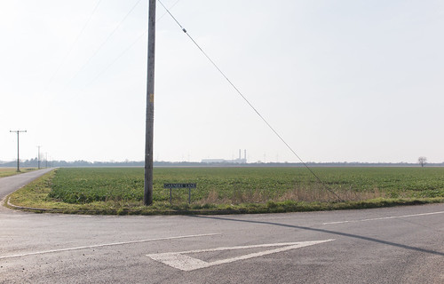
Ground
Zero: Garner’s Lane which crosses the old Wingland Marsh
near Sutton Bridge, Lincolnshire, England.
In 1216 this was all estuary sands. If you stand there confronting this view,
you are looking inland, up the estuary, the sea is
behind you, and the baggage train crossed from left to right in the distance,
probably where the line of trees now is.
These trees line the modern road between Cross Keys and Long Sutton where the
ancient trackway was thought to be.
Now imagine you’re standing in 2 and a half feet of water, which is flowing
slowly from a point in front of you
towards a point behind you – when it suddenly speeds up and sweeps you off
your feet.
How far the wreckage got, rolling and
tumbling on its way towards where you’re standing, is anyone’s guess.
-- Michael Alan Marshall (Researcher)
* From a psychological viewpoint, in contrast with the archetypal, dramatic scenario where a wagon train hastening across treacherous sands is engulfed by an incoming tide, the relatively mundane claim that they had entered an outgoing tide too soon seems a rather strange thing to say -- unless it be true.
** It is improbable in the extreme that he would have even allowed his treasure out of his sight, --let alone have allowed it to go sailing away onto the high seas with men he'd never even seen before.
*** Even without a maelstrom, try standing on a sandy beach and dropping some coins just over the back of your shoulder. Then, turning round, see how many you can find.
**** However if this treasure was John's, then why would 3 separate sources make up a story of him losing his treasure in the Wellstream? Coggeshall's account, written 4 years later, even accurately reports the state of the tide that day -- which looking back over 4 years could not have been guessed or then accurately worked out. Although some people may have been looting Newark, the possibility does remain that some (or most) of John's treasure was lost in the Wellstream and the rest stolen.