My Real-Life Search for
Pirate
Treasure
Nearly 50 years
ago I deciphered a mysterious treasure map which had lain unsolved in the
British Museum. The chart subsequently went missing -- but too late -- I had
already discovered the mysterious island depicted on it.
This is the story
of what happened next.
**Note: The links on this page have, for some strange reason, lost
their colour and reverted to the same colour as the main text.
I have therefore underlined them to make them easier to spot **
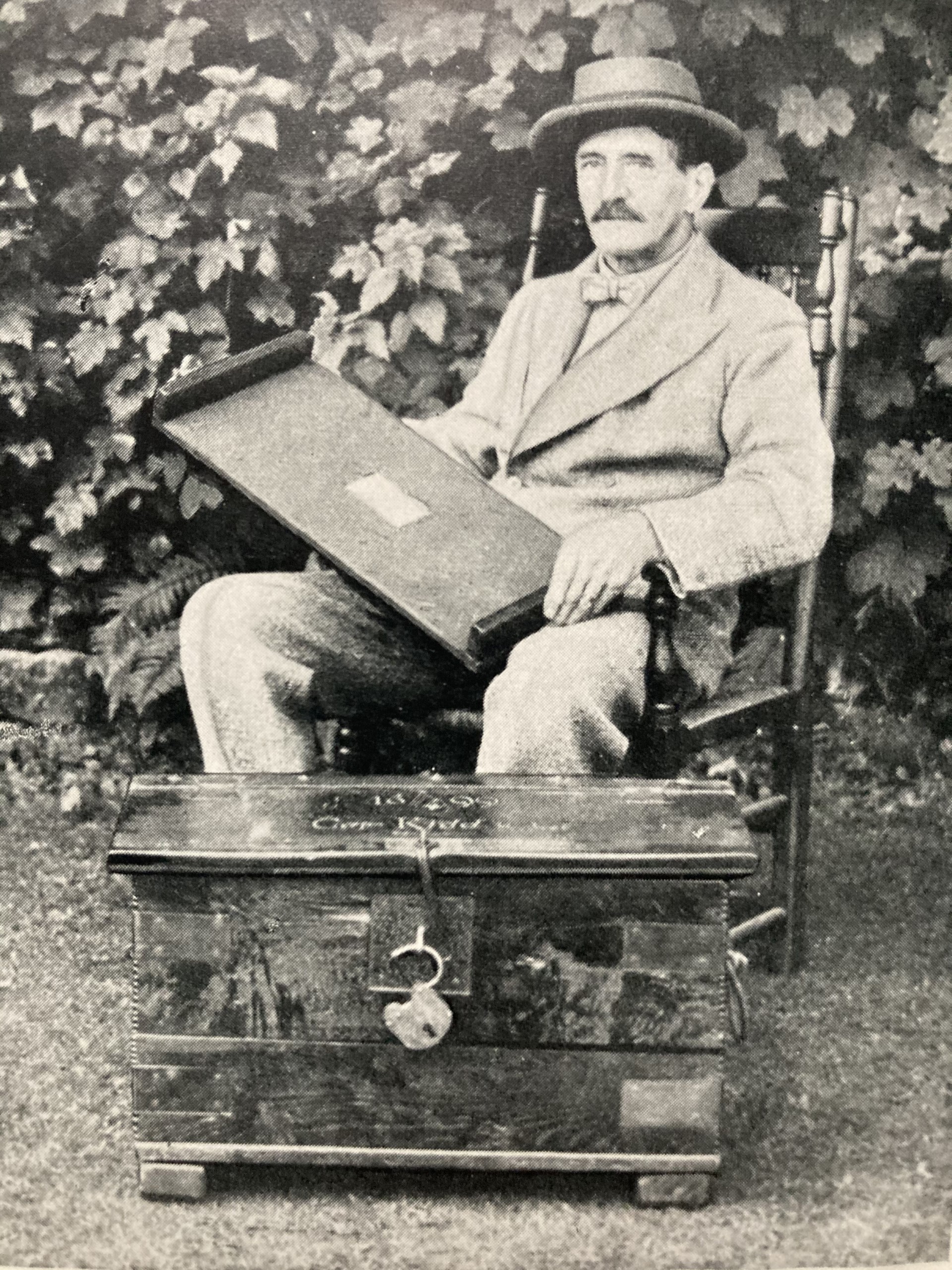
Hubert Palmer, the discoverer of
the map, and the strange chest in which he found it.
My story begins before I was
born. Long before. In 1929 a retired lawyer named Hubert Palmer, who was also a
collector of antiquities, perchanced to walk into a
dusty old antique shop in Eastbourne on the south coast of England, where he
saw an old wooden chest which was being offered for sale. The shopkeeper told
him that the box had been brought in by an old maid, one Miss Pamela Hardy, who
was a direct descendant of Captain Thomas Masterman Hardy of the famous warship
HMS Victory. He had acquired it, she said, from a descendant of one Ned Ward,
who had been the bosun of none other than Captain William Kidd.
It bore a brass plate which
read, "Captain William Kidd, Adventure Galley, 1669".
Upon purchasing the chest and
taking it home to examine it, he discovered a secret compartment which
contained an old book, dated 1662. To his utter astonishment, there, tucked
inside the front cover of the book, was an ancient parchment chart which depicted
a tropical island. This mysterious island, wherever it was, was embellished
with coco palms, reefs and rocks, an anchorage, hills
and valleys, but no “X marks the spot”. There was, however, a rather cryptic
looking message around the periphery of the chart.
Now to those with only a common
street-knowledge on any subject outside of his ordinary life, this subject, let
alone its active pursuit, must seem fanciful and childish. Nor would many
ordinary people even be able to tell you whether William Kidd really existed;
the times I have seen the looks upon peoples' faces when this topic was raised
-- looking at me as though I were an overgrown child, while their own lack of
intelligence and knowledge prevented them from putting two and two together and
realising that university calibre people are simply not that stupid and
therefore there must be a lot more to it.
William Kidd was a Scot. He was
born at Dundee about 1645, probably the son of a Presbyterian minister, and
about the first 45 years of his life we know next to nothing. However in the 1690s he turned up in New York, which had
until recently been called New Amsterdam, as an apparently respectable merchant
shipowner. He lived at number 56 Wall Street, long before the famous stock
exchange was ever built. But he seemed to have a past; rumours abounded that he
had risen into his position by having been a pirate once, and the authorities
too seemed to know something of this when they later chose to hire him, for the
inside knowledge which they seemed to know he possessed, to clear the Indian
Ocean of pirates.
You see, the Moghul of India,
who held pretty much life-or-death powers over the East India Company (which
annually sent untold riches back to Britain), had loudly complained to
Britain's King William III that English pirates were attacking and looting his
ships on the high seas.
And so that same year King
William commissioned Kidd to fit out a navy vessel, the "Adventure
Galley" and sail for the Indian Ocean. But he had sailed no
further than the Nore, an island in the river Thames half way
between Greenwich and the sea, when a group of seagoing freebooters came aboard
and shanghai'd most of his crew. And so, rather than
face the embarrassment of returning to Greenwich with next to no crew, he
limped across to New York where he found himself with no alternative than to
recruit the only people he could quickly muster -- his old piratical cronies
from the quayside alehouses. And they all sailed off….
Needless to say
the voyage was Kidd's absolute undoing. Lacking the natural qualities of a commander, and finding himself so obviously in the presence
of a bunch of old sea dogs and scalliwags, saltwater
bandits of the worst ilk, he barricaded himself in his cabin while they helped
themselves to whatever merchant shipping caught their fancy. Meantime the
Moghul of India must have looked on in utter, aghast astonishment at what
appeared to him to be William III's response to his plea, while William III
himself must have gone completely ballistic.
In his attempt to regain
control Kidd killed his motley crew's ringleader, one William Moore, by
smashing a bucket over his head. This worked -- he regained some semblance of command but the episode only served to worsen his prospects
in the long run. Sailing into the Caribbean in 1698/9, he abandoned the
Adventure Galley for a small sloop, then cautiously sailed for New York to
discover the truth about his position. Lacking the bottle to sail straight into
New York harbour, however, he sailed on instead to Boston where there were
dignitaries he knew. But that didn't help either. Ships travelled slowly in
those days, way slower than the Moghul's galloping post horses, and upon
arrival Kidd was quickly arrested and transported to London in February 1700,
thrown into Newgate Prison there (now the Old Bailey)
and arraigned to stand trial for Piracy and Murder.
The trial, which was heard in
1701, was highly dubious, the Government's main objective being of course to
appease the Moghul, and to this end vital evidence in Kidd's favour was
suppressed and withheld. For example Kidd had
plundered two French ships, fair game because England and France were at war at
the time, but the passes which proved their nationality and which Kidd
dutifully handed in to the British Government, went conveniently missing and
didn't turn up again until the 20th Century. Although Kidd had seized an Arab
treasure ship called the Quedagh Merchant, it became
clear overall though that Kidd was a patsy, a fall guy, a sacrificial lamb
whose conviction was going to be essential to placate the Moghul, who by now
was threatening to dismantle the East India Company and cut off trade with
England altogether. Kidd was found guilty and sentenced to be hanged in chains.
No surprises there then.
Now Kidd enjoyed privileges in
prison, which included his being allowed to keep his furniture with him in his
cell, and from here, shortly before his execution, he wrote to Robert Harley,
Speaker of the House of Commons, a letter which tantalisingly read:
In my proceedings
in the Indies I have lodged goods and treasure to the value of one hundred
thousand pounds, which I desire the Government may have the benefit of, in
order thereof I desire no manner of liberty but to be kept prisoner aboard such
ship as may be appointed for that purpose, and only give the necessary
directions, and in case I fail therein I deserve no favour but to be forthwith
executed according to my sentence.
Sir,
your unfortunate humble servant,
Wm Kidd
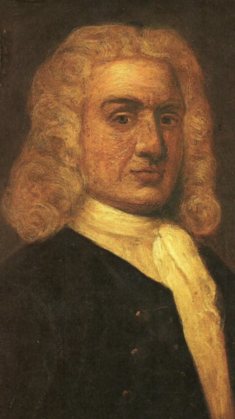
Captain William Kidd. He looked
nothing like the dark, swashbuckling pirate of legend,
and seems to have had a rather mild, "Now now
lads" kind of demeanour. He could not control his crew.
So Kidd had admitted in writing, to no less
than the Speaker of the House of Commons, that he'd stopped off somewhere
between the Indian Ocean and Boston and hidden a hundred thousand quidsworth of treasure. He had obviously suspected during
his return voyage that he was by now outlawed, and that he might need money for
a life outside of society, which he had obviously not wished to take back to
New York with him. And now, he was offering to recover this treasure,
under Government supervision, in exchange for his life.
But as we have seen, the Government
could hardly afford to take him up on his offer. They knew that trade losses
with India would soon far exceed the value of Kidd's hoard, and
also the Opposition in Parliament were having a whale of a time calling
the Government a "confederation of pirates".
So they hanged him instead, on May 23, 1701
at Execution Dock, Tilbury Point, London. In the crowd that day was someone he knew --- his bosun Ned Ward. Before the rope took
him, Kidd shouted out to Ned that his (Kidd’s) ghost would haunt him if he ever
broke open his personal chests. And then he was hanged.
And perhaps the story might
have ended there. But then, in 1929, almost in our own times, Hubert Palmer
walked into that dusty old shop and made his tantalising discovery, and in the
six years which followed he discovered, this time in chests which he deliberately
traced, secreted in hidden compartments, no less than three more ancient
parchment charts, all of which seemed to depict a second island.
I solved those as well, but more on that later.
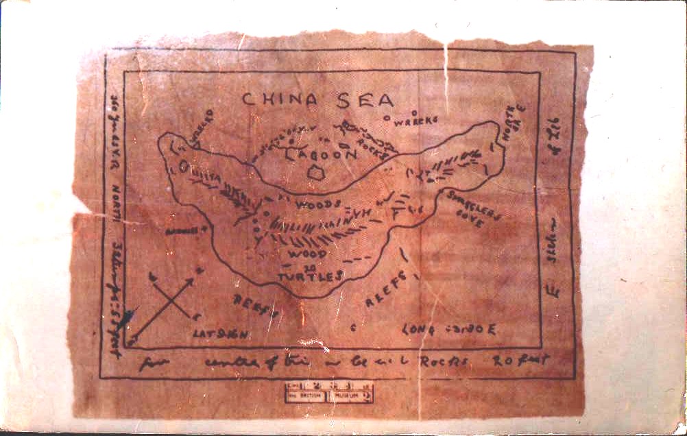
Chart 1
This was an incredible
discovery. The charts were examined by R. A. Skelton (1906 - 1970),
Superintendent of the Map Room in the British Museum, who concluded that the
parchment and the ink were consistent with genuine 17th century charts and the
handwriting on them was compared to known examples of Kidd's handwriting
preserved in the Public Records Office in London, and
proved to be identical.
But Palmer soon discovered that
the latitude and longitude marked on the first chart was false, and he then
spent the rest of his life vainly trying to solve this map. Alas he died
without succeeding, and on his deathbed he is reputed
to have quoted old Sir Walter Raleigh:
These
charts, I think the fairies have the making of. For they bewitch sober men.
And so, for a while at least,
the charts passed to the British Museum. *
Then, in 1972, a British author
called Rupert Furneaux came along with his
book, The Money Pit Mystery, and without any real evidence at
all he likened all four charts to Oak Island in Nova Scotia, where a treasure
hunt, to which Kidd 's name had been attached without a shred of evidence, had
been in progress since 1795.
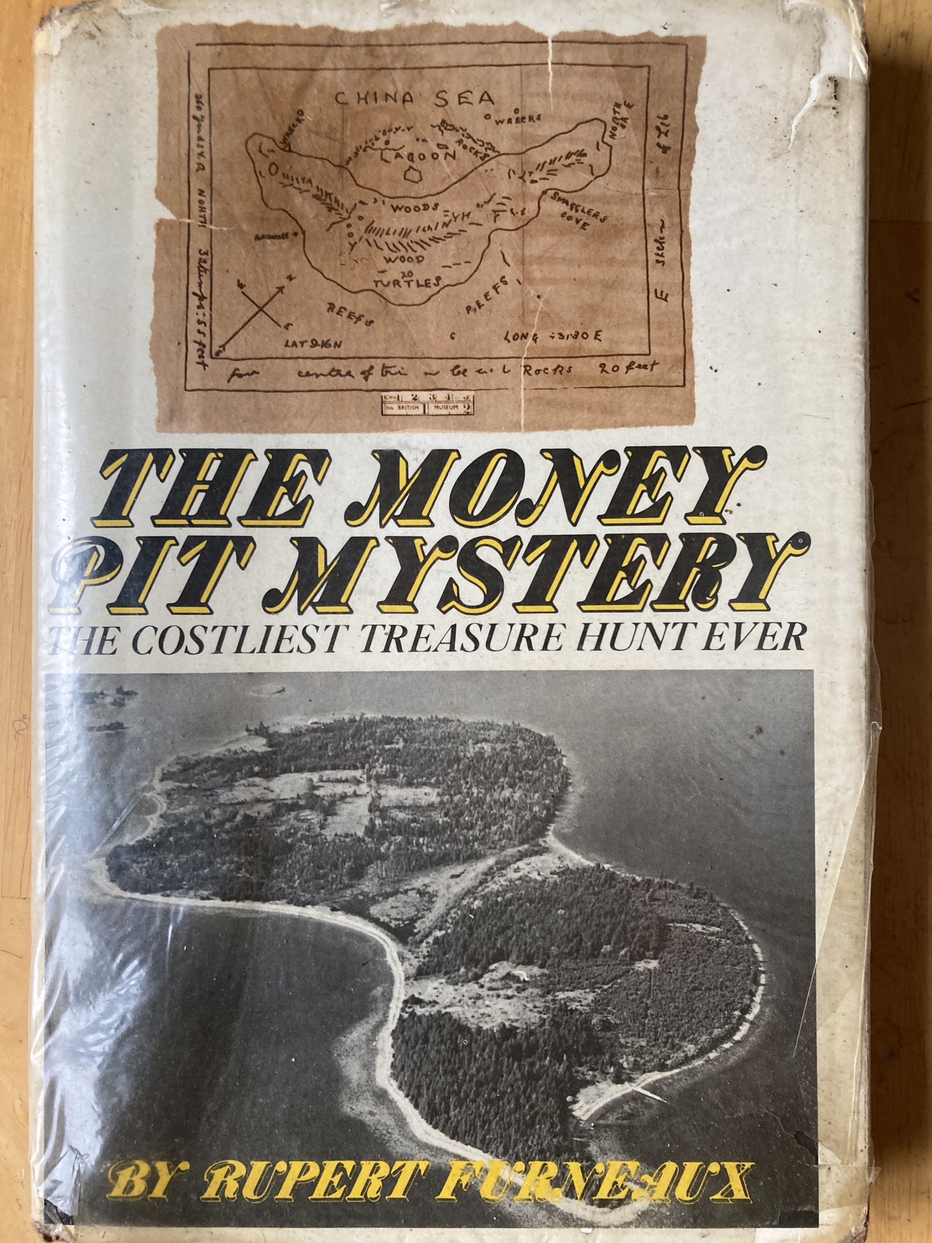
The Money Pit Mystery by Rupert Furneaux. What started
me off on this project was the
fact that I didn't think the tropical island on the chart (top of front
cover) was
anything like Oak Island in Canada (bottom). The guy had the wrong island. So
where was the right one?
Well I read this book, but it soon occurred to
me that the islands on the museum charts didn't look much like Oak Island at
all. Further, Oak Island was a colder, northern place, whereas the mysterious
islands on the charts were tropical, with a lagoon, reefs, and coco palms etc.
And so, realising that the islands had still not been identified, I began to
look much closer at the charts, starting with the first one (Chart 1 above)
which was also by far the most detailed.
So there was this island, then, sunning
itself in some warm sea, and all around it was marked the strangest, most
cryptic writing. But the symbols didn't seem to make any sense at all.
But then I remembered
something. Kidd had been the son of a Presbyterian minister and would probably
have gained from him some knowledge of Greek, as it was from this language that
the scriptures were translated. I looked again at the chart. And …yes! These
mysterious symbols were Greek! There was Greek writing on here!
But to my horror, I saw that
the true longitude and latitude was not included in what the Greek had to say.
And without that, I was nowhere.
Now I don't know what made me
do this, but one night I just said, "William, if you're up there, then
please help". And that was most out of character for me. Having been born
upon Midsummer's Night in a place which has since become notorious for being haunted, and having been born into a family soaked in
religion, I had reacted adversely to all that kind of stuff and become very
secular. I got little sleep that night. Dreams about this and that, about
mirrors and images turning upside down and inside out, about cryptic messages
and geometrical shapes breaking up and re-forming....
But then, next morning, I went
straight to the chart and, looking at it in just a certain way, my mind in just
a certain mode, I saw a code! And there it was! The real longitude and
latitude! Excitedly I turned to a world atlas and there, sure enough, with the
latitude dead accurate and the longitude just a little out, was a tiny
dimensionless dot. But the map wasn't detailed enough to reveal the shape of my
little dot. I needed to know the shape of my little dot! So
I rushed down to the university library and turned the place upside down
looking for a more accurate map -- but to no avail.
And so, I then became rather
cloak and dagger and wrote off to American intelligence. I explained to them
that I was a geology student studying sand bars and spits, and I requested an
aerial photograph of my little dot.
It seemed like forever before
it came. But one morning it duly arrived. And -- of all the millions of random
shapes that you can imagine for an island -- this is what my little dot turned
out to be.
My tiny dot (above), Bonaire in
the Caribbean, was almost identical to the mysterious island on the
chart.
Calculate the odds against that!
You can imagine how ecstatic I
was! I had solved the chart!
I looked over the photo with excitement.
At the place marked 'Anchorage' on the chart there was a tiny inlet from the
sea which opened out into a huge natural harbour more than half a mile wide,
the small triangle on the chart which stuck out from the shore near the top
left corner of the island turned out on Bonaire to be a large triangular
obelisk, the small island in the 'lagoon', Klein Bonaire, was right there
exactly as on the chart, and the overall correlation between the shorelines of
Bonaire and the chart was better than I could possibly have hoped -- and
certainly beyond all coincidence.
Here, now,
for the first time, is my complete decipher of the chart.
There then followed a 5 year period where I left university halfway through the
course, buried my treasure files in a bank vault under the streets of Sheffield
and went out to work to try to raise the money to visit my island. During this
time I also opened a dialogue with the Dutch government (the Netherlands being
the island's jurisdictional nation), which involved ministers and even the
Prime Minister of the Netherlands Antilles, in documents
which you may now see.
But meantime my humble
employee's efforts to raise the kind of capital that would be needed for this,
were coming to nothing, despite my living like a recluse and working every hour
God sent, and so in 1980 I very reluctantly resorted to a change of tack -- and
approached the British media.
Well they thought my material was highly
interesting, infectious even, and following a centre page feature in the Daily Star national
newspaper, and subsequent features in other newspapers and magazines as well as
television and radio interviews, sponsorship was soon forthcoming. And so,
after 5 years, myself and a small search party first set foot upon the island.
It was September 1980.
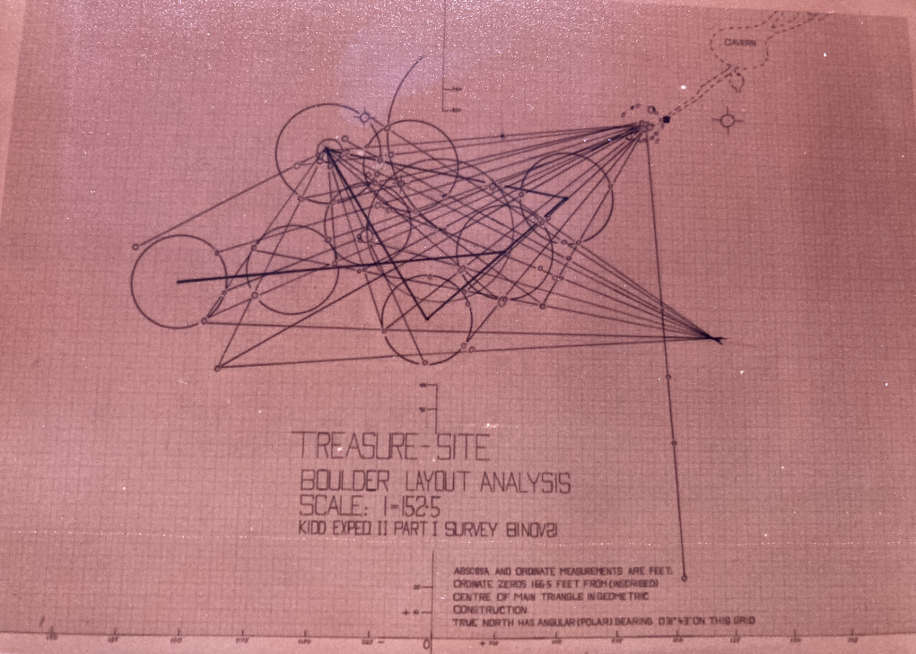
We immediately set out to
locate and explore the focal place on the chart, where the construction lines
intersected, and waiting for us there was a field of boulders, very large, which seemed
to line up onto an especially massive boulder in the centre of what seemed to
be a geometrical construction.
Now this visit was merely a
preliminary reconnaissance one, but on the next visit in early 1981 we
thoroughly surveyed the place and mapped the area
around the "Key Rock," as we called it. Incredibly, the
construction turned out to have several features. First, not only did the
smaller rocks (but they still weighed tons) align onto the Key Rock, but they
also cross-aligned onto three tree stumps. These stumps were bleached white
with age, and actually tasted of salt from the
moisture in the sea breeze which constantly swept through the place.
Tantalisingly, the museum chart read "3 stumps". Were these the
stumps?
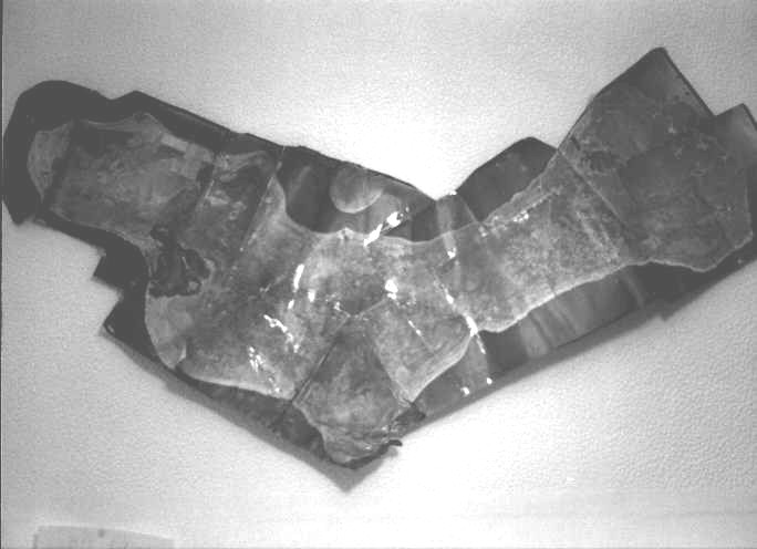
The boulder field.
The boulders themselves appear as small circles on the survey chart. They were
laid out in 20 ft diameter
circles and the centres of the circles made a triangle, the area of
which was exactly the same as the
product of 55 and 20, both key numbers on Chart 1.
This photo has coloured due to age.
Well at first, and for a long
time, we naturally thought that perhaps the Quedagh
Merchant's treasure (for presumably that was where Kidd had obtained it) lay
under the Key Rock as the metal detectors were giving a particularly strong
signal there. We began to excavate, but to our frustration we discovered only
bedrock-- pure diabase. But the detector signal was still there! Now this was
very perplexing, and we just couldn't think of an explanation.
Until, that is, we heard from
locals about the cave system under the island....
It was with a mixture of
excitement and apprehension that we contemplated entering these large caves,
which were set in a long crag over on the eastern side of the island. In the
meantime, still expediting things honestly and not wishing to trespass (less
still remove valuables from someone's land!), we sought and entered
into two legal contracts with the landowners, Sylvia and Milton, who
actually lived in New Jersey, Sylvia being a Public Notary there. One
contract covered searching, and the other covered the freighting of any
recovered valuables out of there. We also agreed to hold everything until they
got there, which would be a while due to the pressures of their business back
home.
We duly met in the spring of
1982, having first bumped into each other when we both independently chose the
same plane from New York to Curacao. Mid flight I was walking along the aisle
in the economy class when I saw this woman seated ahead, reading a letter
in my handwriting, the one I had written to Sylvia some
time before.
Travelling the rest of the way
together, we arrived at Bonaire and the next day Milton showed us one of the
caves. This was a voluminous formation, with stalagmites and stalactites, and
which had natural rock ledges here and there upon which people long ago had
obviously rested oil lanterns, as the lumps of carbon from them were still
there. These I later had radiocarbon dated, to discover that they dated to the
right period (1650 - 1700), but alas those records were destroyed in 2000. A
few days later Milton and Sylvia returned to the United States.
Meantime, very strange things
were emerging from our survey of the boulder field. I discovered that the
boulders didn't only cross-align onto the 3 ancient tree stumps, but that
groups of them also formed perfect circles, and joining the centres of these
created a large triangle, the area of which, 1100 square yards, was identical
to the product of the two main numbers, 55 and 20, on the chart! There was
also another stone row within this construction, which was not part of the triangle but which converged with the longest side of the
triangle at a point about half a mile away, which when I tracked it down turned
out to be an open hole, about 2 feet deep, in which were small fragments of
some kind of wood. Loose rocks, not very large, had also been piled up beside
this hole, but there was no earthen mound to indicate that the hole had ever
had any soil in it.
At length we entered and
explored the cave system and made the discovery of our lives. There was writing
on the walls and, incredibly, the initials WK and a year, 1698, over a small
tunnel going back into the rock but which had been blocked by stones. The date
1698 puzzled me a bit, because we knew that Kidd didn't arrive in the Caribbean
until the spring of 1699. However further research revealed that back in those
days they actually counted the years from April to April (news to me, and you too I bet), and so his likely arrival time of March 1699
was still considered 1698.
Alternatively, the date 1698
could be a record of the seizing of the treasure of the
Quedagh Merchant, and the message, in common with
gravestones in a cemetery, records the event and not the interment;
-- "the 1698 treasure."
However, curiouser and
curiouser, we were, as far as we could calculate, right under the key rock and
there was no metal detector signal down here. Emptying the tunnel, which was
not very long at all but did contain a particularly tricky boulder....revealed nothing and crashed in an instant our most
excited hopes. Then, after a very thorough search of the entire cave
system also revealed nothing, we returned to the Key Rock location on the
surface, rechecked our survey figures, and scanned again with metal detectors
-- to discover the signal still there!
It was then that we noticed the
light green rocks at that location....copper ore.
But what of the "WK" and the wall writing? By then, however, there
were locals who knew about us, and who had a sense of humour especially on this
subject, and to this day I still wonder if they had not pranked us.
At this point, a very thorough search having been done, I ended the project.
Having assimilated all the data on the chart we had run out of places to
search, and I guess it had always been true that in the case of treasure hidden
on land, as opposed to that lost under the sea where in those days no one could
get at it even if they knew exactly where it was, it is always possible, or
even likely, that one of the many people involved in its secretion may have
later gone back for it. For example, of all the tombs in the Valley of
the Kings in Egypt, only one -- one
-- has ever been found intact with treasures still there, and even that
had, it was discovered, been broken into but the robbers had been caught red
handed.
But of course, I still could not have done things any differently. After all,
suppose it had still been there and I hadn't even
bothered to go and search? It is not something that we can work out on a blackboard,
and there really is nothing for it but to go and look.
Which leads me on to those
remaining charts. Now are they of the same island, or do we have another one?
Now as I have already said, I
solved these too.... but at this point the plot thickens further.
Now I could never help but
suspect that there was indeed something very fortuitous about Hubert Palmer's
original discovery. Had he faked the charts? But if they bore Kidd's
handwriting upon them, then how could he have done so?
Ok, so perhaps you
might have thought that the geometrical part of the first chart was impressive.
But at this point, however, we start to get into some really
deep and mysterious waters. Here is another of those charts which Hubert
Palmer revealed to the world.
This is more crudely drawn, and the cipher written beneath it reads:
515 SE and by 50N
36NE 36 NE Rocks
3 feet by 3 feet
by four
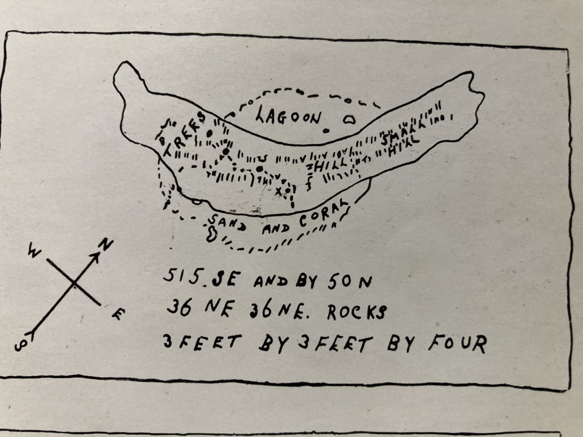
Chart 2
Now that last bit, 3 feet by 3
feet by four, I would specifically ask you to mark in memory. Read on....
Another chart, shown below, is
also most interesting. It is supposed to have been drawn from imagination by
Harold Tom Wilkins, author of "Captain Kidd and his Skeleton Island"
(1935) upon a request from his publisher who suggested that the drawing might
better fire the imagination of his readers.
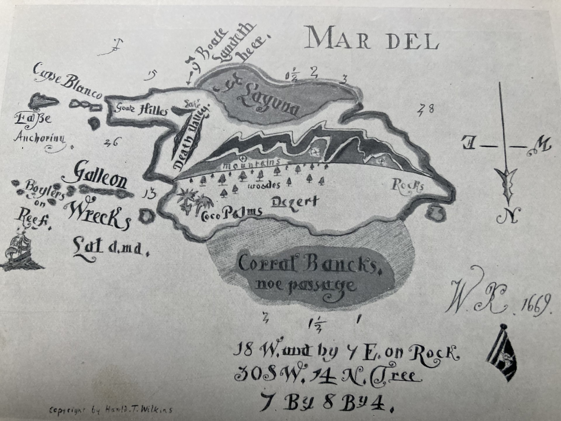
Chart 3
Now this chart looks very like
Oak Island, and perhaps there is nothing strange in that; after all, the
treasure hunt on that island had been going on for a very long time and was
very famous in Wilkins' days. In a Freudian sense, maybe that shape just stuck
in his mind.

Oak Island in Nova Scotia,
Canada. Nothing to do with us, but it does look a lot like Wilkins' "made
up" chart.
However -- everything to do with us -- the message, "7 by 8 by 4" on
Chart 3 correlates with the
longitude of Robinson Crusoe Island. What did Wilkins know?
But is this part of the story
that simple? Look at this:
Wilkins'
"made up" chart reads beneath it:
18W and by 7E on Rock
30SW, 14N Tree
7 by 8 by 4
Now again hold in your mind
that last bit, "7 by 8 by 4", and look at this:
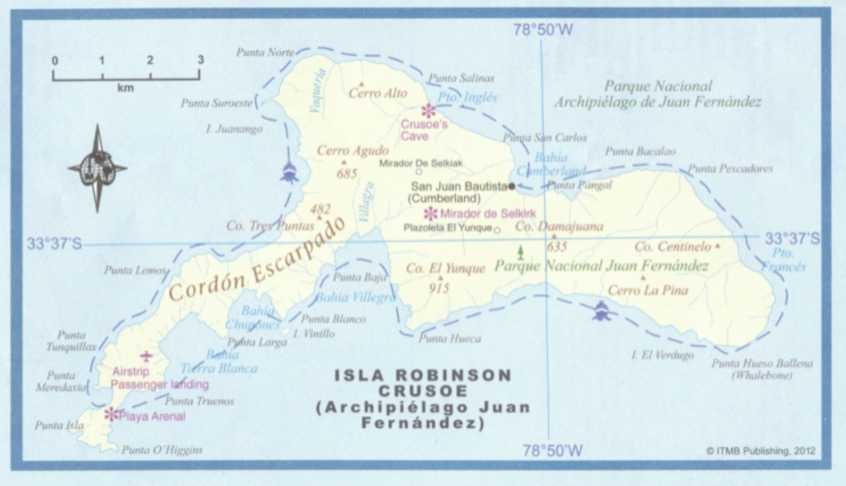
Isla Mas a Tierra (Robinson
Crusoe Island) in the Pacific off the coast of Chile.
Note the latitude and longitude, 33' 40" S and 78' 40" W, and then
compare these with
the message on Chart 2 -- "3 feet by 3 feet by four", and the message
on Chart 3 -- "7 by 8 by 4".
Note also the general shape of the island.
This is the Isla Mas a Tierra,
better known as Robinson Crusoe Island. It lies in the Pacific, in the southern
hemisphere, and it belongs to Chile.
Robinson Crusoe
Island Lat 33 deg 40 ' S,
Long 78 deg 40" W
Now, what were
those two sets of numbers I asked you to
remember, one from Palmer's chart and the other from the "imagined"
chart of Wilkins?
"3 feet by 3
feet by four" .....and ..... "7 by 8 by 4"
Now compare these numbers with
the numbers contained in the latitude and longitude of Robinson Crusoe Island.
A coincidence? Not on your life.
Each of these numbers, 334 and 784, is a 3-digit number. Placed together
therefore, we have a statistical probability of one chance in one
million that these two sets of numbers, comprising six figures in
all, is a coincidence.
Further, we have a piece of
human psychology here in the fact that both charts, allegedly the work of
different creators, record their 3-digit number at the bottom of the message,
and both form the last line of a 3 line set of
directions. The psychological structuring of the lines seems so similar from
one chart to the other that even a slightly inebriated observer might suspect
that both are the work of the same mind.
I had noticed all this by 1983,
the year after our Bonaire work ended. Shortly after making the project's film I contacted the
Government of Chile, who were duly fascinated. I began to explore with them
groundwork of perhaps working on at least a tv documentary, but these were the
days of the dictator General Pinochet, thousands of people were going missing,
and I had a young wife, a little child and a baby on
the way. After a short time I thought better of it,
and the subsequent explanatory meeting I had with them tested my diplomatic
talents to the extreme. I did however obtain from them a solemn promise that
they would send a team out to Crusoe Island and mount a thorough search, and I
later heard that this had been done with nothing of substance having been
found.
Four years later in 1987 I
swore an affidavit
to record this discovery, and then, walking out of the lawyer's office I asked
myself out loud, "Just what on earth is going on here?" And so I had discovered, and then filed away, the Kidd-Palmer
link with Robinson Crusoe Island.
But the mystery remains. Wilkins' map was supposed to have been dreamed up, by
Wilkins, to please his publisher. Yet we have seen to within a tolerance of one
part in one million that he cannot have dreamed it up. So
Wilkins knew something about Robinson Crusoe Island and so did Palmer. In other
words, these two men were linked in some way. We do know that Wilkins saw the
Palmer charts, but the Palmer charts don't include the 7-8-4 number sequence. On the basis of what knowledge could Wilkins have seen
Palmer's 3-3-4 chart and then come up himself with 7-8-4 to demark an island
(Robinson Crusoe) -- which was also strikingly similar in shape and features to
Palmer's 3-3-4 island?
Commonsensically the conclusion
here has to be that Palmer and Wilkins have colluded
together, they both knew about both charts, and they both knew about Robinson
Crusoe Island.
Now this of course doesn't mean
that there was no treasure on Robinson Crusoe Island. But what you are about to
read next might mean that...
You see, the longitude of
Robinson Crusoe Island makes it a rather cunning choice for a secret place --
but not to someone who lived in olden times. Allow me to explain. Most
people imagined that North America, on the globe, was immediately above South
America. But it isn't. In fact, if you slide North America due south, it almost
completely misses South America. North America is significantly further west
than South America, which means that the longitude of Crusoe, in the Pacific
off South America's west coast, is the same as the longitude of
the once pirate-infested eastern seaboard of the Carolinas in
North America, and the latitude, expressed as 33 deg 40 N instead of 33 deg 40
S, is also precise for the Carolinas, once infested by pirates such as Edward
"Blackbeard" Teach and others.
So if anyone were to stumble
upon the secret latitude and longitude encoded in the Wilkins map and the
Palmer 3-3-4 chart (Chart 2), i.e. 33' 40 and 78' 40 (notice that north, south,
east and west are not mentioned on the chart), they would automatically look on
an atlas at 33' 40 north and 78' 40 west, while assuming that 33
'40 south and 78' 40 west would be somewhere in the middle of the
Argentinian pampas. And so Robinson Crusoe Island
might escape detection. But the point is that this deception
only works if we have maps accurate enough to make it clear
that North America is very far to the west of South America, and also accurate
measurement of longitude -- which Kidd didn't have and
which didn't come along until relatively modern times. This indicates strongly,
though not conclusively, that Crusoe as a concealed location has been chosen by
the mind of a modern forger.
But it gets even weirder. We've already seen that the geographical features on
Chart 1 place beyond all doubt the conclusion that Chart 1, the chart concerned
with my expeditions, is of
Bonaire -- as if I didn't already know that from my discoveries there. But
where it gets weirder is that there is a date on the Wilkins chart -- 1669 --
which not only appears on the brass plate found on the chest which contained
Chart 1 but was also the date of the sacking of Maracaibo, just a stone's
throw from Bonaire, not by Kidd but by Henry Morgan.
Now Bonaire was uninhabited
between 1650 and 1700, and was both the first and the
only island that Morgan would have come to after sailing away from the looting
of Maracaibo, before heading out over the open sea for his home base in
Jamaica. Morgan would not have been wise to take his booty straight home with
him, as he seldom operated with Royal permission and might well have had the
lot confiscated when he got back. And, sure enough, these buccaneering capers
were to land him in trouble with the Crown more than once.
Henry Morgan. In 1669, the year
mentioned on Wilkins' chart, he raided and sacked
Maracaibo which is only a stone's throw from then uninhabited Bonaire. It
would
have been foolish to return directly to Jamaica with his plunder and Bonaire
was the
only uninhabited stop-off along his return route.
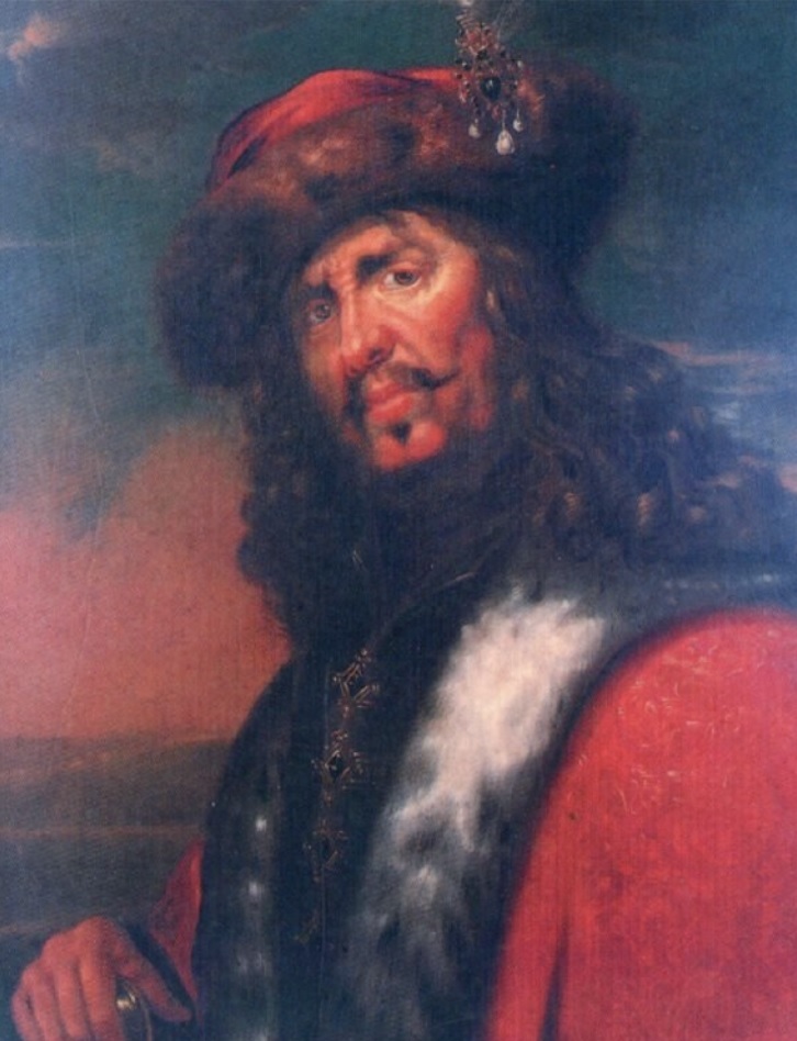
William Kidd in his youth may have been one of Morgan's men.
Is it possible that Morgan had
originally buried treasure on Bonaire, and Kidd had not obtained his from the Quedagh Merchant at all, but had had knowledge of Morgans
activities, perhaps through having been one of Morgan's men in his youth?
Remember that reputation the middle aged Kidd had in
New York, which was why the King commissioned him?
But the point is also that this
date, 1669, also connects Wilkins and his Chart 3 with Chart 1!
Today, after much additional research in 1987, the best I can do to put this
whole thing together is to conclude, rightly or wrongly, that all the charts
were forged by Wilkins and a man named Guy Palmer, Hubert's brother,
immediately after Wilkins wrote "Captain Kidd and his Skeleton
Island" in 1935. They then visited Bonaire and set up the
geometrical boulder field (which would however have required some very heavy
lifting equipment, not unlike the masonry elevating stuff which Kidd loaned to
Trinity Church in Wall Street when they were building the place) and probably
the rock filled tunnel and the wall writing in the cave, intending to go back
later, perhaps as part of a follow-up book -- but this project abruptly ended
when Guy died a few years later in 1940, leaving all that they had planted
there for the next explorer, myself, to find.
The only thing which confounds
this conclusion, and points to everything being genuine, is the claim by Furneaux that the charts contained Kidd's handwriting and had been
thoroughly examined by the British Museum. But he gave no reference
for this.
I am no longer involved in this
mystery. I have discovered what I have related to you here,
and filed it away long ago. Those files I dutifully kept for thirty
years, in case anyone should have any questions or enquiries, but some were
lost in 2000, and almost all destroyed in 2013, so now, ten years even further
on, little remains. However, what I have written here I gladly share with you.
You figure it out. All I can do now is lead you back full circle to Hubert
Palmer and that deathbed quote of old Sir Walter Raleigh:
These
charts, I think the fairies have the making of,
For
they bewitch sober men.
But.... Kidd, the Palmers,
Wilkins... who's really been doing the bewitching?
--- Michael Alan Marshall